
Destinations & itineraries · 03 Jun 2026 · 8 min read
Climbing La Soufriere in Guadeloupe: everything to know before scaling the volcano
La Soufriere peaks at 1,467 m above Basse-Terre, the highest point in the Lesser Antilles and the main active volcano in the French Caribbean. The classic ascent takes 3 to 4 hours round trip from Bains Jaunes (950 m), with no technical equipment, on a marked trail in the heart of the Guadeloupe National Park. […]
La Soufriere peaks at 1,467 m above Basse-Terre, the highest point in the Lesser Antilles and the main active volcano in the French Caribbean. The classic ascent takes 3 to 4 hours round trip from Bains Jaunes (950 m), with no technical equipment, on a marked trail in the heart of the Guadeloupe National Park. Here is everything you need to know before setting off.
What exactly is La Soufriere of Guadeloupe?
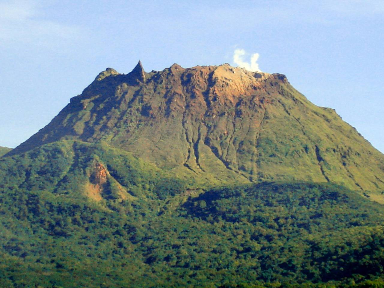
La Soufriere is an active Pelean-type volcano, roughly 100,000 years old, that towers over the island of Basse-Terre. Its activity is monitored around the clock by the Volcanological and Seismological Observatory of Guadeloupe (OVSG-IPGP), which operates a network of more than 200 stations, over 60 of them automated and real-time. The last major phreatic eruption dates back to 1976: it led to the evacuation of 73,422 residents from southern Basse-Terre over three and a half months, one of the largest civilian evacuation operations ever carried out in France.
The summit is home to several craters bearing historic names: Tarissan, Dupuy, Napoleon and the South Crater. On clear days, the plumes of sulfurous steam escaping from them are visible from the Caribbean Sea, a natural landmark instantly recognizable from the deck of a catamaran anchored off the leeward coast. The Guadeloupe National Park, which protects 17,300 ha of tropical forest including the volcanic massif, has been a UNESCO Biosphere Reserve since 1992.
How does the ascent of La Soufriere unfold step by step?
The classic ascent links four clearly distinct sections from Bains Jaunes. Each stage has its own atmosphere and its own demands: dense, humid forest at the bottom, a windy plateau halfway up, bare volcanic rock at the summit. The total elevation gain is 528 m over 6.4 km round trip.
Bains Jaunes (950 m) - the starting point
Bains Jaunes is the usual starting point for the ascent. The car park is free and has around 15 spaces, which makes setting off early (before 7:30 a.m.) essential, otherwise you may not find a spot. A stone’s throw from the car park, the natural sulfur-water pools sit at a temperature of 26 to 30°C: many hikers save them for the way back. The site is located 5 km from Saint-Claude via the D11.
Le Pas du Roy - the tropical forest (950 m to 1,140 m)
The first section, the Pas du Roy, climbs from 950 m to 1,140 m in about 30 minutes on a paved trail of colonial origin. The vegetation is exuberant: tree ferns, bromeliads clinging to branches, mosses carpeting the stones. The wildlife is discreet but present. You may catch sight of the Lesser Antillean hummingbird (endemic to the Lesser Antilles) or hear Pinchon’s robber frog, a tiny tree frog whose clear call rings out through the canopy.
La Savane a Mulets (1,140 m) - the windy plateau
At 1,140 m of altitude, the vegetation thins out and the wind picks up. La Savane a Mulets is an open plateau from which the view opens onto Marie-Galante, Les Saintes and, on exceptional days, Dominica. The former car park on this plateau was permanently closed in 2004 after the collapse of Piton Tarade. This is where you should pull out the windbreaker: the temperature difference with the lower stretch is noticeable, and the wind can be strong even in fine weather.
Le Chemin des Dames - the final climb (1,140 m to 1,467 m)
The Chemin des Dames is the most demanding section: 300 m of positive elevation gain over about 1 hour 15, on increasingly mineral terrain. You cross the Grande Faille, a geological scar opened by centuries of volcanic activity. The trail then skirts the area of the Faujas landslide, which occurred in 1798 and profoundly reshaped the northern flank of the volcano. The final 50 metres before the summit are crossed on wooden stairs fixed directly into the rock.
The “La Decouverte” summit (1,467 m)
At the top, the marked point La Decouverte at 1,467 m offers a 360° panorama over the Guadeloupe archipelago. On clear days, you can make out Piton Dolomieu (1,464 m, the second highest point in the Antilles), the neighbouring islets and, towards the northwest, the Caribbean Sea in all its expanse, the exact mirror of the panorama you get from a catamaran anchored offshore. The three main craters (Tarissan, Dupuy, Napoleon) ring the summit; the sulfurous fumaroles there are continuous.
What is the real difficulty of the La Soufriere hike?
The La Soufriere hike is rated moderate and remains accessible to a family with children from the age of 8 to 10 in good physical condition. No alpine technique is required: the trail is marked along its entire length, and the National Park installed ONF emergency markers on the route in 2025. The descent can prove more slippery than the climb in wet weather, which is frequent.
The real limiting factor is not physical effort but the weather. La Soufriere generates its own microclimate: fog shrouds the summit more than 300 days a year, sometimes making the hike visually pointless or even dangerous in zero visibility. The OVSG publishes real-time weather data via a webcam installed at the summit. In the event of high volcanic risk, the National Park can close the trail by prefectoral decree. An accredited guide is required only to access the immediate surroundings of the active craters, not for the classic trail up to the summit.
When to go and how to prepare for the climb?
The weather, the hiker’s first enemy
Setting off before 7:30 a.m. is the golden rule: mornings are generally clearer, and fog tends to form in the middle of the day on the heights. Check the OVSG webcam before leaving your starting point. The dry season (carnival period, from January to June) statistically offers more clear windows, but no month is guaranteed.
The essential gear
Plan for high-cut hiking boots (the paved trail can be very slippery), a waterproof windbreaker and a light fleece for the summit, 1.5 to 2 litres of water per person and a change of clothes for the way back. If you want to enjoy the Bains Jaunes after the hike, bring a swimsuit and a towel.
How to reach Bains Jaunes from Bas-du-Fort
From the Bas-du-Fort marina, where passing catamarans often anchor, Bains Jaunes is about 1 hour’s drive via the RN1 national road then the D11 towards Saint-Claude. A rental car is the most logical option from a catamaran: it offers the flexibility to combine the hike with other sites on the same day, without depending on public transport schedules that do not serve the heights.
What to combine with the climb during a stopover in Guadeloupe?
The ideal day for a sailor on a stopover starts early with the climb to La Soufriere (departure at 7 a.m., return around 11:30 a.m.), followed by a swim in the Bains Jaunes, then lunch in Saint-Claude before heading to the Carbet Falls in the afternoon.
The Carbet Falls are located in Capesterre-Belle-Eau, about 30 minutes’ drive from Bains Jaunes via the D4. In 2026, the site is open every day from 7 a.m. to 5 p.m. with rates set until 2028: 6 € for an adult, 4 € for a child under 12, and 14.50 € for a family pass. The 2nd fall (110 m) is the most accessible, with a 45-minute round trip from the welcome area. For everything about access to the Carbet Falls, find the full details in our dedicated article on the Carbet Falls in Guadeloupe.
For sailors who want to organize their stopover in Guadeloupe aboard a catamaran, Sailoe offers catamaran cruises in the Caribbean departing from Bas-du-Fort (Guadeloupe) between December and April. The team replies within 24 hours to any quote request at +33 2 97 84 61 61 or by email at charter@sailoe.com. Discover the full Sailoe offer in the Caribbean.
Frequently asked questions about climbing La Soufriere
How long is the La Soufriere ascent round trip?
Allow 3 to 4 hours round trip for the classic ascent from Bains Jaunes (950 m) to the La Decouverte summit (1,467 m). The elevation gain is 528 m over 6.4 km in total. Confident hikers can complete it in 3 hours, while families with children should plan for closer to 4 hours.
Do you need a guide to climb La Soufriere?
No, the ascent to the summit does not require a guide. The trail is marked and ONF emergency markers were installed on the route in 2025. An accredited guide is required only to access the surroundings of the active craters, areas strictly regulated by the National Park.
What level of difficulty is the La Soufriere hike?
The hike is rated moderate, accessible from the age of 8 to 10 with no particular physical issue. No mountaineering technique is required. The main risk is the slipperiness of the trail in wet weather and the fog at the summit, which can make the hike uninteresting or dangerous in zero visibility.
How should you dress to climb La Soufriere?
Plan for high-cut hiking boots, a waterproof windbreaker, a light fleece (the temperature at the summit can drop by 10 to 15°C compared to sea level) and 1.5 to 2 litres of water per person. A change of clothes for the way back is recommended.
Where do you park to start the hike?
The Bains Jaunes car park is free and has around 15 spaces. It is located 5 km from Saint-Claude via the D11. Set off before 7:30 a.m. to be sure of finding a spot, especially in high tourist season.
Is La Soufriere dangerous to climb?
The ascent on the marked trail presents no particular danger in normal conditions. The National Park monitors volcanic activity continuously via the OVSG-IPGP (a network of more than 200 stations) and can close the trail by prefectoral decree in the event of increased seismic or volcanic activity. Before any hike, check the alerts in force on the Guadeloupe National Park website.
Read also · Destinations & itineraries
Related articles
The Bay of Les Saintes, Seen From a Catamaran That Stays the Night
The Bay of Les Saintes, south of Guadeloupe between Terre-de-Haut and Terre-de-Bas, is usually visited in three hours, squeezed between two shuttle…
Where to Dive in the Seychelles on a Catamaran Cruise?
From a catamaran at anchor, scuba diving in the Seychelles is possible at dozens of sites around Mahe, Praslin and La Digue,…
Wingfoiling in the Seychelles: spots, winds and best season
The Seychelles offer an ideal window for wingfoiling from June to September, driven by the south-east trade winds that blow between 15…
Got a project in mind?
Our team is here to help
30 years of expertise, 5 physical bases, our own fleet. We reply within 24h.
Start the conversation