
Destinations & itineraries · 03 Jun 2026 · 9 min read
La Maddalena Scenic Drive: Touring the Island in 20 km
The La Maddalena scenic drive is a 20 km loop that follows the coastline of the main island and reaches its finest beaches. You can do it by car, by bike or on foot, allowing around 2 hours to make the most of each stop. From a catamaran at anchor, these same beaches reveal themselves […]
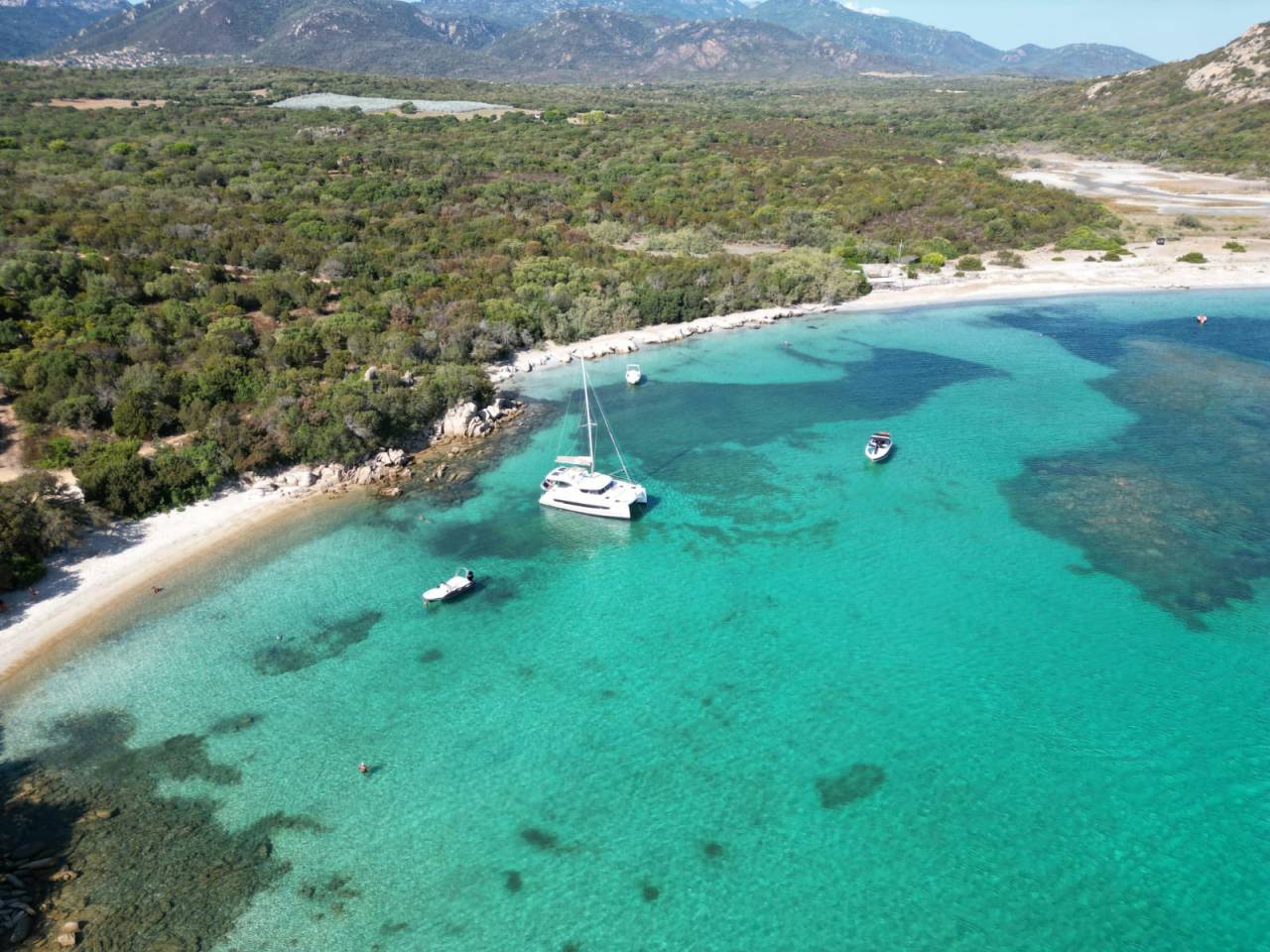
The La Maddalena scenic drive is a 20 km loop that follows the coastline of the main island and reaches its finest beaches. You can do it by car, by bike or on foot, allowing around 2 hours to make the most of each stop. From a catamaran at anchor, these same beaches reveal themselves from a different angle: the pink granite and the coves emerge with no filters or tourist signposting, seen from the water.
What is the La Maddalena scenic drive and how do you do it?
The Strada Panoramica (SP114) is a 20 km coastal road that loops around the main island of the La Maddalena archipelago, with possible starting points from the port town to the south. It can be travelled by car, by bike or on foot, and links the island’s four major beaches while offering several viewpoints over the surrounding islets.
The full route takes around 2 hours if you take the time to stop at each beach. The road is paved along the main SP114; some secondary access tracks to the beaches are dirt roads and require some manoeuvring. Note that military zones on certain sections impose passages with no stopping allowed. Several “Punto Panoramico” viewpoints are signposted along the road, including a panoramic bar at the highest point with an open view over the archipelago’s islets. For those arriving by catamaran from the sea, the scenic drive is the natural land-based complement: as you approach the island, you can already make out from the cockpit the outlines of what you will later explore on foot.
What are the must-see stops on the scenic drive?
The scenic drive reaches four main beaches and several viewpoints, each with a distinct character: sheltered waters to the north, wild beaches to the west, pink granite everywhere. Here are the stops not to miss.
Spalmatore - the bay sheltered from the Mistral
Spalmatore is the only beach on the island sheltered from the Mistral, the north-westerly wind that blows regularly over the archipelago. It is a decisive advantage on days of strong breeze: the water stays calm and shallow, ideal for families with children. The pink sand beach is split in two by a jetty, which creates two distinct atmospheres. A snack bar offers drinks, ice creams and panini on site. Parking is along the roadside, with no official car park - it is best to arrive early in high season. From a catamaran at anchor in the bay, the reflection of the pink granite in the turquoise water reveals itself without any filter: this is where you understand why this cove withstands the winds when the exposed shores are whipped up.
Bassa Trinità - the wild beach and its dunes
Bassa Trinità is a large light-sand beach with shallow water for several metres, extended by dunes and golden scrubland. Access from the SP114 is marked by a turn-off; parking is along the road. Wooden walkways cross the dunes to reach the sand without damaging the vegetation. The seabed is good for snorkelling, with polished rocks and varied underwater life. A walk along the shoreline lets you reach Spiaggia del Morto. From the sea, the dunes and golden scrubland that border Bassa Trinità make it recognisable from afar as you sail along the coast by catamaran: it is a natural landmark before you can even make out the beach itself.
Cala Francese - pink granite and the quarry’s history
Cala Francese is a pretty cove with turquoise waters surrounded by scrubland, with a rare historical feature in the archipelago: it was a former pink and white granite quarry, active until the Second World War. The site is now home to the Historic Quarry Museum, open to the public, with a via ferrata, old machines, a quarry train and period cranes. This granite was exported for buildings and monuments around the Mediterranean, including a monument in Ismailia on the Suez Canal. A large car park borders the SP114; the secondary dirt-road branches towards the neighbouring coves are narrow and call for some manoeuvring. From an anchorage at Cala Francese, the pink granite walls cut vertically by the quarrymen are visible from the water - a setting the road does not let you see from this same angle.
Monti d’Arena - the large golden sand beach
Monti d’Arena is one of the island’s few large beaches with a notable width. The sand is golden, the shallow waters form lagoons in the backdrop, and big granite boulders frame the beach on either side - you can climb them for a panorama over the whole site. There are no permanent facilities: it is best to bring water and a picnic. Parking is possible in the small roadside car park or below the access path. From the sea, the granite boulders that frame Monti d’Arena look like natural ramparts - you can recognise them from the cockpit before you can even make out the sand.
Which direction should you drive the La Maddalena scenic route?
Most visitors set off from the port of La Maddalena and first follow the north-east coast, which lets you finish along the west coast at sunset. This anticlockwise direction is recommended for one simple reason: the west coast is wilder, brighter at the end of the day, and the panoramic bar at the highest point then offers a view over the islets bathed in raking light.
Set off early in the morning to avoid the afternoon heat and to find parking spaces at the busiest beaches. Allow around 2 hours for a relaxed tour with stops. On some sections running alongside military zones, stopping is forbidden - the road passes through with no possibility of parking. Access to the secondary beaches branching off the SP114 is signposted but sometimes narrow.
What else can you see at La Maddalena from the scenic drive?
The scenic drive overlooks one island, but the archipelago has seven - Caprera is a stone’s throw away via the Moneta bridge, and the wildest islands (Spargi, Budelli, Santa Maria) can only be reached by boat. This is where the visit takes on another dimension.
Caprera, linked to La Maddalena by the Moneta bridge, is home to beaches even wilder than the main island, as well as the Garibaldi museum (2026 price: 8 € for the house-museum, 12 € for the combined memorial ticket, free for under-18s). Cala Coticcio on Caprera, sometimes nicknamed “the Tahiti of the Mediterranean”, has required since 2026 the presence of an authorised guide and the payment of a 3 € environmental contribution via PagoPA. To explore further on foot, the hiking trails of Caprera cross the island’s interior and ridges with views over the archipelago - find the details in our article on hiking in Caprera.
For the other islands - Spargi, Santa Maria, Razzoli, and Budelli with its famous pink beach visible only from the sea - the only way to reach them is by boat. Budelli’s pink beach has been protected since 1994 by the La Maddalena Archipelago National Park (more than 20,000 hectares of land and marine areas): access to the shore is forbidden there, but the view from the water is striking. For those sailing aboard a catamaran, this is the advantage of sailing over the scenic drive: the entire archipelago opens up, with no ferry or parking constraints.
To discover La Maddalena and everything the island has to offer beyond the scenic drive, see our article on things to do in La Maddalena. And for those who wish to explore the archipelago from the sea, by crewed catamaran, Sailoe runs cruises departing from Corsica - a way to see these landscapes as few visitors do: from the water.
How do you get to La Maddalena to start the scenic drive?
La Maddalena is reached by ferry from Palau, about 3 km away on the Sardinian coast - the crossing takes 15 to 20 minutes. This is the standard access for the vast majority of visitors.
Two companies run the link: Delcomar and Maddalena Lines. In high season, departures are every 30 minutes from Palau. Fares start from 4 € one way for a foot passenger; the fare for a vehicle varies depending on the season and the size of the boat. You can bring your car aboard or rent one on site - there is no public transport covering all the beaches on the scenic drive, which makes a car or bike essential for a full tour. For sailors arriving by sea from Corsica or directly by catamaran, the La Maddalena archipelago opens up with no ferry or parking constraints. Discover our cruises in Corsica and the archipelago’s anchorages.
Frequently asked questions about the La Maddalena scenic drive
Can you drive around La Maddalena?
Yes, the 20 km scenic drive is entirely drivable by car, except for a few sections near military zones where stopping is forbidden. The surface is paved along the main SP114; the secondary accesses to the beaches are sometimes dirt roads and require some manoeuvring. Allow around 2 hours for a relaxed visit with stops at the main beaches. It is best to set off early in the morning in high season to find parking spaces.
What are the must-do things at La Maddalena?
The 20 km scenic drive and its four beaches (Spalmatore, Bassa Trinità, Cala Francese, Monti d’Arena) form the heart of the visit to the main island. The boat trip to the uninhabited islands of the archipelago (Spargi, Budelli, Santa Maria) is often cited as the highlight of the stay. Caprera, linked by the Moneta bridge, offers wilder beaches and the Garibaldi museum. To go further on the island’s activities and sites, our article on things to do in La Maddalena lists the essentials.
How do you visit the La Maddalena archipelago?
The main island is reached by ferry from Palau (15 to 20 minutes, Delcomar and Maddalena Lines companies, every 30 minutes in high season). The neighbouring islands - Spargi, Budelli, Santa Maria, Razzoli - can only be reached by boat: an organised excursion departing from Palau, a private boat or a catamaran. Caprera is linked to La Maddalena by the Moneta bridge and can be explored by car or on foot.
Is it possible to anchor a catamaran in the La Maddalena national park overnight?
Since June 2026, a new regulation (33/2026) governs navigation in the archipelago. Overnight mooring on official buoys remains possible in the zones designated by the Park Authority - Porto Palma and Cala Portese at Caprera, and the Budelli area in particular. Speed is limited to 7 knots within 500 metres of the shore, and to 10 knots between 500 and 1,000 metres. As the regulations are constantly evolving, it is advisable to check the Park’s official announcements before each sailing season.
Read also · Destinations & itineraries
Related articles
The Bay of Les Saintes, Seen From a Catamaran That Stays the Night
The Bay of Les Saintes, south of Guadeloupe between Terre-de-Haut and Terre-de-Bas, is usually visited in three hours, squeezed between two shuttle…
Where to Dive in the Seychelles on a Catamaran Cruise?
From a catamaran at anchor, scuba diving in the Seychelles is possible at dozens of sites around Mahe, Praslin and La Digue,…
Wingfoiling in the Seychelles: spots, winds and best season
The Seychelles offer an ideal window for wingfoiling from June to September, driven by the south-east trade winds that blow between 15…
Got a project in mind?
Our team is here to help
30 years of expertise, 5 physical bases, our own fleet. We reply within 24h.
Start the conversation